Collision Point
by
Samuel Halpern
Introduction
We
all know that the Titanic sank about 2 hours and 40 minutes after
colliding with an iceberg on her maiden voyage on the night of April 14, 1912. Thanks
to the discovery of the wreck in 1985, we now know exactly where she foundered.
But what does that tell us about the location of where the collision actually
took place? This
question was one of several questions put before the accident investigators of
the Marine Accident Investigation Branch (MAIB) of the Department of Transport
in Southampton in 1992 as part of their reappraisal of evidence relating to the
Californian affair. The conclusion of both MAIB investigators was that
the Titanic was in the approximate position of 41° 47’ N, 49° 55’ W when
she struck an iceberg at 23:45 (11:45 p.m.) ship’s time on April 14, and in
position 41° 43’.6 N, 49° 56.9’ W when she foundered. How was this collision
point derived? As explained in the MAIB report written by the Deputy Chief
Inspector James De Coverly:
“This is
the one almost fully
substantiated piece of
new evidence since the 1912 Inquiry. Dr. Robert
Ballard, leader of the expedition which found the wreckage, gives the position of
the boilers and stern section, and the Inspector
supports his view that these very heavy items will
have sunk almost straight to the seabed: their
position must therefore be very close indeed to the position of
sinking. I agree.
The position is 41° 43’.6 N, 49° 56.9’ W. This will not
of course be the position of the
collision, as the ship must have drifted some distance before she foundered;
how far and in what direction will have depended entirely upon the current, for
the night was calm with virtually no
wind. The current is discussed below, for it is
an important feature in this reappraisal: there is strong
evidence that it was
setting a little west of
south at rather more than 1
knot. Allowing such
a current, and working back from the position of sinking, the position yielded
for collision with the berg is approximately
41° 47’ N, 49° 55’ W. This
position is substantially different from that given by Titanic
in her wireless distress messages and accepted
by the Court of Formal Investigation, namely 41° 46’ N, 50° 14’ W.”
And in the discussion
about the local current, De Coverly wrote:
“The position of the flotsam as
given by the Californian,
when compared with the position of sinking as
now established, is further evidence of a
southerly set and - assuming the position
to be correct - allows it to be
quantified: the direction of set
was about 196° True and the rate
about 1.3 knots. There is
still further suggestive evidence in support of
these figures in that, when run back to give the likely position of
collision, the position arrived at, though
different from that sent by Titanic
in her distress calls does lie practically on
the line of her
course through that position. Perhaps the error in the position as
transmitted was caused by the wrong distance
being allowed along the course line from the last known position –
a simple mistake to make under stress…I
think there can be no reasonable doubt that a
current setting about south by west at something like 1¼ knots existed in the
area of the accident.”
What the report did
not do is provide the specific details of their work. In this article I will try to explain how the MAIB derived their
estimate for the collision point that they gave. What I will also explain is
why this may not be quite right even though it would not be too far off. I will
also show how we can derive a reasonably confident estimate of where the Titanic
came to a final stop in the water several minutes after the collision. I will
then explain how we can get a better feel for where the collision with the
iceberg took place when considering her post collision maneuvering.
The
MAIB’s Collision Point
The
key component in the MAIB’s derivation of the collision point was an estimate
of the local current. Based on information provided in the log of the Californian,
and presented in testimony before the British Wreck Commission, the Californian
left the scene of the floating wreckage at 11:20 a.m. on the morning of April
15, 1912. The position of that wreckage was given as 41° 33’ N, 50° 01’ W. The
position of the Titanic wreck site used by the MAIB was 41° 43’.6 N, 49°
56.9’ W, which is the position of the stern section on the bottom of the
Atlantic as given by Dr. Robert Ballard. The Titanic was reported to
have foundered at 2:20 a.m. What the MAIB inspectors did was to take the
distance between those two locations, 11.04 miles, and divide that by 9 hours
of time to get an average current drift of 1.23 knots, which was referred to as
“something like 1¼ knots” in De Coverly’s report.[1]
The course line between the two locations gave them a current set of 196.2°
true. To get to their collision point they then applied this current in reverse
for 2 hours and 35 minutes, the time difference between 11:45 p.m. on April 14
and 2:20 a.m. on April 15. That would take them 3.17 miles at 016.2° true (the
reciprocal of 196.2°) to a point at 41°
46.6’ N, 49° 55.7’ W. But it also
appears that they allowed the ship to drift about ½ mile westward after
striking the iceberg before it became dead in the water. Thus they backed the
stopping point by that amount to get an assumed collision point at 41° 47’ N,
49° 55’ W when they rounded the coordinates to the nearest minute of arc.
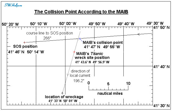
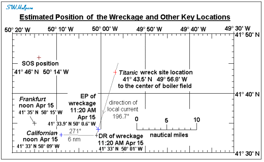
The
chart below shows the key locations of the wreck site, the observed wreckage on
the morning of April 15, the SOS position given out in Titanic’s wireless
distress messages, the 266° true course line used by Titanic’s fourth
officer Joseph Boxhall in getting to that position, and the estimated position
of the collision point derived by the MAIB inspectors.
A
Navigational Reappraisal
When
one looks closely at the methodology used by the MAIB inspectors there are few
things that come to light. First was the assumption that the position of the flotsam
reported in the log of the Californian was the correct position of the
wreckage, and that the current can be estimated by dividing the distance
between that position and that of the wreck site by 9 hours. A second
observation is their apparent assumption that the collision point was slightly
east and a little north from the ship’s final stopping point as can be seen in
the chart above. So let us examine both
of these and see what we may need to change in order to get a slightly more
realistic solution.
Captain
Lord of the Californian had estimated the location of Titanic’s
wreckage by working backward from his noontime observation of the sun that was
taken after he departed the wreckage area Monday morning. This procedure, where you apply your course
and speed for a known interval of time to derive another position is called
dead reckoning, and the position you obtain is called a “dead reckoning
position,” or simply a DR. It does not take into account the effect of any
current or wind on the movement of the ship which is generally unknown to begin
with. Captain Lord’s noontime position was fairly accurate as it involved a
noon observation of the sun which put him at 41° 33’ N, 50° 09’ W. This was a
noontime fix.[2] About the
time this observation was taken, the Californian was coming out of a
large ice field heading westward. The ice field stretch from far to the north
to far to the south and was reported as being 5 to 6 miles in width. As the Californian
was coming out of this pack ice the Frankfurt was seen steaming down
parallel to the western side of the field coming from the northwest and heading
SSE. Both ship’s spotted each other within minutes of local apparent noon. From
the Frankfurt, the Californian was seen off their port bow.
Captain Hattorff of the Frankfurt reported reaching 41° 35’ N, 50° 15’ W
at a time that corresponded to 15:20 GMT,[3]
which for that date and location, was 1 minute before local apparent noon. From
these two position reports, the two ships would have been less than 5 miles
apart.
So
with this observational evidence, it appears that Californian’s position
at local apparent noon on April 15 was correct. But what about the location of
the wreckage? According to Captain
Lord’s testimony, the time they left the floating wreckage and abandoned
lifeboats was 11:20 a.m. ship’s time.[4]
Reading from his logbook: “11.20 proceeded on course N. 59 W. by compass.” When
asked by Sir Robert Finlay what would that be in degrees true (as opposed to
degrees magnetic), Lord replied: “I think I was intending to make N. 89 W [271°
true]. I think that was my intention. The variation is 23½, and I think the
deviation was 5.” Captain Lord was also asked about the speed they were going
after leaving the wreckage. His reply was simply: “I went slow. I came through
the ice full speed to the ship [Carpathia], but I went back slow.”
According
to Californian’s Chief Officer George Stewart, between 11:20 a.m. and
noon they traveled some four or five miles going through the ice. The actual
distance between the reported locations is almost exactly 6 miles. But we also
know from Captain Moore of the Mount Temple that the ice field was about
5 to 6 miles in width down in the vicinity of the wreckage. This tends to
support the distance traveled that Stewart estimated and agrees very well with
the 6 miles between the coordinates of the wreckage and the coordinates of
their noon sun sight.[5]
How
fast was the Californian going as it cut through the ice? GMT of local
apparent noon for the Californian on April 15 at longitude 50° 09’ W was
24 hours and 11 minutes later than GMT of local apparent noon for April 14 when
she was at 47° 25’ W on her way to Boston. This means that the time of local
apparent noon on an unadjusted clock set at noon the previous day would be 11
minutes past 12 o’clock. Therefore, the
difference in time between leaving the wreckage at 11:20 a.m. and local
apparent noon when they took that sun sight was 51 minutes, not 40 minutes as
one might assume it to be.[6]
A distance of 6 miles in 51 minutes gives a speed over ground of just over 7
knots. As we have seen from Captain Lord’s statement, the ship’s heading was
271° true.
Finding Current Set and Drift
If
the local average current is known, a navigator can apply that as a correction
to a DR position to get what is called an “estimated position,” or more simply
an EP. However, the local current on the morning of April 15 was not known, so
the position of the wreckage was a DR position based off of the Californian’s
noontime fix. What Captain Lord did was take his noontime location, 41° 33’ N,
50° 09’ W, and run it back at a speed of 7 knots till 11:20 a.m. on the
reciprocal of his course heading, or 091° true. That gave him the position of
41° 33’ N, 50° 01’ for the wreckage when rounded to the nearest minute of arc.
It was a DR position. It was not a fix, nor was it an EP.
To
determine the average current a navigator needs to determine the distance and
azimuth angle between a second fix and its relation to the DR position for the
same point in time. Course and speed changes made between the two fixes only
affects how the DR is obtained, not the determination of the current. As an example, take the situation shown on
the chart below.
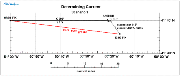
Here
we have a tramp steamer heading due east at a speed of 7.5 knots. Their last
fix was at 08:00 at 41° 40’N, 51° 00’ W. Four hours later, at 12:00, they would
have traveled 30 nautical miles due east to a DR location at 41° 40’N, 50° 20’
W as shown. But at 12:00 a another fix was taken and they found that their ship
was really at 41° 36 ’N, 50° 16’ W. This location is 3 miles east and 4 miles
south of their DR position, or 5 miles at 143.1° true from the DR. They got
there by a current that took them 5 miles off their course over a period of 4
hours. The speed of the current was therefore 1.25 knots.
Now
suppose that at 11:00 they had to stop because of engine problems which took
over an hour to repair. At 12:00 they took another fix and found that instead
of being 22.5 miles (3 hours at 7.5 knots) due east of their 08:00 fix, they
were in fact 3 miles further east and 4 miles south of their 11:00 DR, which
again is 5 miles at 143.1° true from that location. But since they were stopped
for an hour, their DR position for 12:00, the time they took their second fix,
is the same as their DR for 11:00 (which was at 41° 40’N, 50° 30’ W). So once
again they find that a current had set them 5 miles off their course over a
period of 4 hours, and again the speed of that current works out to be 1.25
knots. This second scenario is shown in
the chart below.
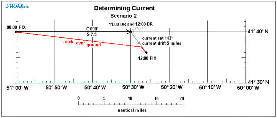
In
both scenarios we get the same current, running 143.1° true at 1.25 knots. The current
was obtained both times by observing the difference between the location of
their second fix and their DR position for that same exact time. The speed of
the current was derived in both cases by taking the distance between the fix
and the DR, which was 5 miles, and dividing that distance by the time between
the two fixes, which was 4 hours apart in both cases. What was different
between the two scenarios is the track of the ship over the ground as can be
seen by comparing the two diagrams. But the derived current, both speed and
direction, came out the same.
In
the MAIB solution, the starting time was 2:20 a.m. at the position where the Titanic
sank, a position that can certainly be regarded as a precise navigational
fix. Their ending time was 11:20 a.m. when the Californian departed the
wreckage area. Their result for the strength of the current was overestimated
somewhat because they used the wrong time interval. They should have used the time
that the noon sun sight was taken upon which that DR location for the wreckage
was based. They also assumed, as in the British Wreck Commission’s report, that
ship’s time on the Titanic was the same as ship’s time on the Californian.
Although the time on their clocks were not too far apart, they were not the
same.
We
will correct these apparent oversights in the next section. We will also take
into account the evidence that strongly suggests that the Titanic turned
northward immediately following the collision, and at one point, her engines
were put ahead again for a short period of time after first coming to an
initial stop. This will then be used to get a somewhat more realistic estimate
for where the collision with the iceberg took place.
Re-Working
the Problem
In
looking to solve the problem, the approach I took was to run time in reverse.
My starting point was the April 15 noontime fix of the Californian, 41°
33’ N, 50° 09’ W. The first leg of the journey is to run at a speed of 7 knots
on a heading of 091° true (the reciprocal of 271° true) for 51 minutes to get
to the DR where the wreckage was seen last. Then, as in scenario 2 above, we
will remain dead in the water floating with the wreckage in reverse until we
take another fix. That fix is the location where the Titanic sank. The
time for this event is taken at 3 minutes before 2:20 a.m., when all of her
lights went out. Lookout George Symons
in lifeboat No. 1:
“I
saw her lights go out, all her lights. The next thing I saw was her poop...It righted
itself without the bow; in my estimation she must have broken in half...I
should think myself it was abaft the after expansion plate.”
Symons said he saw the
stern disappeared from view about 2 to 3 minutes after he saw the ship break in
two. Over on the upper bridge of the Californian
the lights of the steamer that had been firing white rockets had suddenly
disappeared from view. As observed by Apprentice James Gibson:
“Just after two o'clock, she was then about two points on
the port bow, she disappeared from sight and nothing was seen of her again.”
Gibson was then sent
down to inform Captain Lord that the lights of the steamer they were observing
had disappeared. When asked for the time, Gibson replied, “Five minutes past
two by the wheelhouse clock.”
Titanic’s
clock’s had been set last to read 12:00 at local apparent noon on April 14.[7]
Her longitude at noon on April 14 was approximately 44° 31’ W. Californian’s
clocks were set at local apparent noon on April 14 to read 12:00 when she was
at a longitude of 47° 25’ W. The difference in their noontime longitudes would
have meant about a 12 minute difference in their respective clocks. A time of
2:05 on the Californian corresponded to 2:17 on the Titanic, or 3
minutes before the stern section disappeared beneath the surface. And as
observed by George Symons, this was the time that Titanic’s lights went
out as the ship apparently broke apart.
Using
Californian time throughout, the difference in time from 2:05 a.m. to
when Californian’s officers took their noon sighting of the sun is 10 hours and 6 minutes,[8]
the time interval between fixes that we are looking for.
For
the position of our second fix, the Titanic wreck site location, I took
as the center of the boiler field given by Dr. Robert Ballard. This is located
at 41° 43.5’ N, 49° 56.8’ W.[9]
The difference in distance between this fix and the DR position for the
wreckage (at 41° 33’ N, 50° 01’ W) is 11.0 nautical miles. Dividing this
distance by 10 hours and 6 minutes gives a current drift of 1.09 knots. The set
of the current would be the course line from the center of the boiler field to
the DR location which works out to 196.7° true. Now that we have a good estimate for the average current, we can
use this to get an estimated position for the wreckage at 11:20 a.m. instead of
using a DR position. This is obtained by applying the current in reverse for 51
minutes of time starting from the DR position and traveling on a heading of
016.7° true. The result is an EP for the wreckage at 11:20 a.m. at 41° 33.9’ N,
50° 0.6’ W, almost a mile northward from the DR.
All
of these key locations are shown in the area chart below.
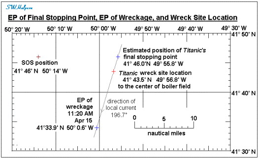
With
the derivation of the local average current we can now find the position of the
Titanic when she came to a final stop after colliding with the iceberg.
This not the same as the collision point. To find the collision point requires
some knowledge about the after collision movement of the ship. But the final
stopping point can be estimated with a higher degree of certainty because it
does not depend on any assumption other than the ship was dead in the water at
a certain point in time.
We
know that the Titanic did not stop immediately after striking the
iceberg. We know this from several sources including greasers Frederick Scott
and Thomas Ranger, trimmer Thomas Dillon, Second Officer Charles Lightoller,
fireman Alfred Shiers, and passengers Henry Stengel, George Rheims, and
Lawrence Beesley. The engines were reported to have ran on for about a minute
or two before coming to a stop and were then backed slowly to take the way off
the ship before they stopped again. We also have some evidence that the engines
were restarted ahead again for a very short time from Scott, Dillon, and
Beesley, and from quartermaster Alfred Olliver and passenger William Carter.
There is some speculation that this was done to move the ship away from some
nearby ice shortly before they gave the order to uncover the lifeboats. Beesley
had observed the ship moving ahead slowly just a few minutes before going off
the boat deck. On his way down the second class staircase he noticed a crew
member starting to uncover lifeboat No. 16 on the port side. The order to
uncover the boats came about 15 to 20 minutes after the collision.
Over
on the Californian Third Officer Charles Groves observed the steamer
that had approached them from abaft their starboard beam appeared to have
stopped with most of her deck lights shut out from his field of view. The time
on the Californian was 11:40 p.m. He knew the time because the
quartermaster struck one bell to inform the oncoming watch to get ready to come
up in 20 minutes to take over the watch on deck. Captain Lord joined Groves on
the upper bridge about five minutes later, 11:45 p.m., to look at the lights of
the stopped steamer. On the Titanic it now would have been 11:57 p.m.,
and close to the time when the order was given to uncover the boats.
What
I have done was assume that by 11:45 p.m. Californian time (11:57 p.m.
on the Titanic), the Titanic was dead in the water for all
practical purposes. As noted above, the time when her lights disappeared from
view was 2:05 a.m. Californian time. The difference in time is 2 hours
and 20 minutes during which the ship would have drifted with the current.
Working back for that amount of time from the wreck site location places the
final stopping point of the Titanic at 41° 45.9’ N, 49° 55.8’ W, which
when rounded to nearest minute of arc is 41° 46’ N, 49° 56’ W. This final
stopping point is shown on the chart below along with the location of the wreck
site and the EP of the wreckage at 11:20 a.m.
To
come up with an estimate for the collision point we need to know something
about the movement of the Titanic before, during and after the
collision. According to lookouts Frederick Fleet and Reginald Lee, the Titanic
had veered to port shortly before striking the iceberg. This is supported by
Quartermaster Robert Hichens who said he received an order to hard-astarboard
the helm shortly before the impact came. We also know from standby
Quartermaster Alfred Olliver that an order for the helm to be put hard-aport
was given as the berg was seen passing down the starboard side of the ship. We
also know from Quartermaster George Rowe stationed on the poop that as the berg
passed his location the ship was not under starboard helm. And we also know
from seaman Joseph Scarrott and fireman Alfred Shiers that the stern of the
ship was veering away from the berg which slowly disappeared off the starboard
quarter. It is reasonably certain that first officer William Murdoch had
ordered the helm shifted to port in order to clear the ship’s stern as the
iceberg glided by along the starboard side. If he had not done so, the allision
with iceberg would probably have opened up the entire starboard side of the
ship resulting in the ship capsizing soon thereafter.
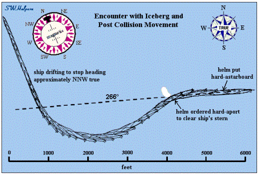
The
collision sequence, derived by taking into account the known turning
characteristics of the ship and its speed of approach, is shown in the
animation sequence below. This animation frames are in 3.75 second increments
but speeded up by a factor of three. The approach course was 266° true, and the
scale shown is 250 feet per grid line. As depicted in a sketch drawn by Frederick
Fleet, the iceberg was placed ahead of the ship fine off the starboard bow as
the ship approached it at a speed of 22½ knots.
Titanic
was turning to starboard soon after striking the berg under port helm. The ship also started to slow as the engines
came to a stop and then were backed for a short time to take the way off the
ship. Somewhere during the starboard turn the helm was steadied up. If a
specific direction was not ordered, the helmsman, Robert Hichens, would have
probably steadied the ship’s head onto one of the points on the compass which
was directly in front of him. It is likely, but not a certainty, that he would
have chosen a cardinal point. In this case it would be magnetic north. Indirect
evidence for this comes from Quartermaster George Row who testified that “her
head was facing north” when he was on the bridge assisting with the firing of
distress socket signals and working one of the Morse signaling lamps out on the
bridge wing. As a quartermaster, it would be quite natural for him to have
looked at the compass as he moved about the bridge while doing that work. And
his reference to direction would be magnet which differed by about 2 points
from the ship’s geographic heading at that location. North magnetic would have
corresponded to NNW true. As the ship came to a final stop, its head may have
fallen off a bit as the rudder lost effectiveness as the ship slowed to a dead
stop.[10]
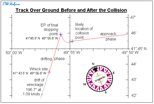
The diagram below
shows the probable track of the ship over ground from just before the collision
to a few minutes after the collision based on the movements described above.
After
the engines came to a stop after being backed for a minute or two to kill the
ship’s headway, the ship was making about 4 to 6 knots through the water, something
observed by Second Officer Charles Lightoller after he got out of his cabin a
few minutes after the collision to look around. The ship would then have
continued to drift forward for the next few minutes before the engines were
restarted again before stopping for a final time. The net result is that the
ship likely traveled as much as ¾ of a mile west and ½ mile north from the
collision point before becoming dead in the water close to midnight on the Titanic.
Working back from our EP for the Titanic’s final stopping point, the
collision point would have been close to 41° 45.5’ N, 49° 55’ W, or about a
mile and a half south of where the MAIB estimated it took place.
The
diagram below shows this collision point in relation to the estimated position
of the final stopping point and the wreck site location. The track of the ship
over ground is also shown, and includes the effect of the local current on the
ship’s course line prior to the collision.
Based
on a confirmed noontime position of the Californian on April 15, 1912,
her reported DR position when she departed the area of the wreckage at 11:20
a.m., and the location of the Titanic wreck site, we were able to derive
the average local area current for the region. Using this estimate we were then
able to derive an estimated position (EP) for the wreckage at 11:20 a.m., and
an EP for where the Titanic came to a final stopping point close to
midnight. Based on the likely movement of the Titanic that followed the
collision, we were also able to derive an approximate position of where the
collision took place. This point was located approximately at 41° 45.5’ N, 49°
55’ W, or about a mile and half south of the collision point derived by the
MAIB.